THE GEOPOLITICAL PLACE
The resident mule deer I’ve been observing live parts of their lives along the Okanogan River, including in a snip of unincorporated land called the Elmway neighborhood. The Elmway deer also range a bit south and west. They visit a residential area at the north end of Okanogan— the town, not the river— and from there, they continue up in elevation away from the river toward an area known generally as “the flats.”
When it was part of my work commute, I regularly encountered deer at two specific locations on the flats above the river and town, spots where locals knew to keep an eye out. The two deer at the very top of the pic below mark those road crossings. It’s the Pogue Flat area: orchards, ag fields, a golf course, and lower density residential where there’s residential at all.
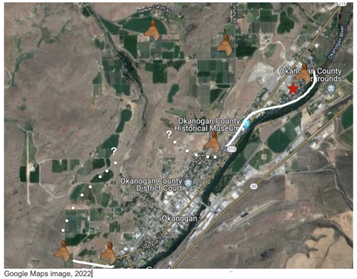
In the Google Maps image above, the Elmway neighborhood is marked with a red star and connected to the residential area beneath the county museum label. The white line shows a path the deer are known to follow. They can walk a dike pretty privately for most of the distance, then they cross a main road at a 35 m.p.h. section and head uphill into the neighborhoods. Off the map in the upper right corner, there’s an orchard at the northernmost end of the Elmway neighborhood. It’s the farthest distance north where I know Pi has been spotted, but I’m skeptical deer go much further, unless they cross the river, because both the geology and infrastructure of the area bottleneck up pretty hard.
Mirroring the north Okanogan deer, there’s a similar deer presence south of Okanogan. The two deer at the bottom of the graphic above mark a neighborhood in south Okanogan and the Okanogan Cemetery. The deer to the left marks the cemetery, which is out of town and heading up in elevation. It’s unlikely the south Okanogan deer come up to Elmway but they’re known to head north of the cemetery toward those green fields. Each little deer population moves uphill and away from the river heading toward each other, toward the Pogue Flat area, but I don’t know if they meet up during any of the seasons. Note the fields on and on the way to Pogue. What deer wouldn’t head that way? But I’m talking largely about does. Bucks aren’t near as visible near the people part of the range. Do the bucks and does “migrate” the range area differently? They must. What are the bucks doing and where specifically are they doing it? There are so many things I don’t know.
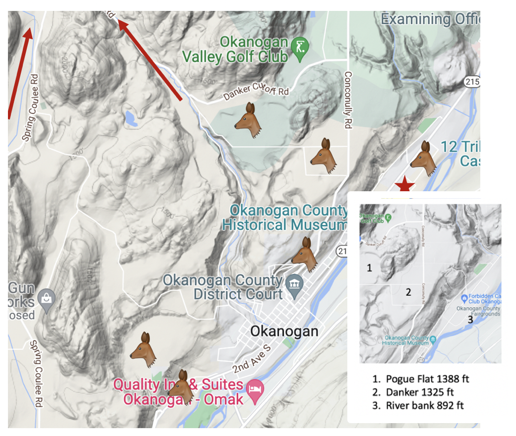
The prior Google photo illustrated how deer are moving around in relation to people and human infrastructure, and the Google terrain pic above shows how they’re also navigating the geography of the place, which is pretty dynamic for a small little spot such as this— river, cliffs, fields, mountains. In the photo above, most everything that’s not the river valley is Pogue Flat. (Elevation in inset pic.) The graphic represents somewhere around 4 square miles. The two red arrows point out Spring Coulee and Salmon Creek which lead further out past Pogue Flat, to ranches and big acreage tracts, dry hills, forests, some creeks and lakes, and then mostly open land for 40 miles as the crow flies until you hit the Pasayten Wilderness.
Knowing where I’d seen deer in the Okanogan Valley for about 40 years is pretty much the only thing I know about deer at all as I start these notes, so I am pretty jazzed to learn there are such things as wildlife regions and game management units and that they coincide with my casual observations. It’s a bit of a no-brainer. It’s how they fit to and use the terrain. Same for humans. The 4 square mile area I’ve described turns out to be located in Region 2, District 6, GMU 233: Pogue Flat, a 228 square mile area.
The map below puts the Elmway neighborhood into perspective within the larger Pogue unit, which probably tops out at an elevation of about 4000 in its north and west. I can’t imagine the doe I’m seeing are ranging far enough out to hit that elevation. My guess is there are smaller residential families / herds using sections of the unit and ranging a few miles around them, and at least during parts of the year, the does and fawns are circled up together. I’d also guess the bucks are ranging much further. I’d be curious how different deer at the far edges of the wilderness are from the little city deer on Elmway, if at all. But again, I have no idea what I’m talking about.

WDFW 2021-2022 Game Management Units map
Questions, questions, questions…
So I know there’s a management system, but at this writing, I have no idea what it is or whether anyone is actually paying attention to the “Pogue” deer down in the river valley. Does anyone count them? Consider them during fires and bad winters? Are their numbers considered in the permit management system or are they too insignificant? What are their numbers? How do we even count deer? Do the south and north deer gather together in a larger herd on the flats? Are they all part of what’s considered a “herd?” What the hell is even considered to be “a” herd? What are the GMU’s based on?
We’re 7 people per square mile out here, though we’re clustered pretty tightly in the little towns. There’s about 2500 people in Okanogan. The deer use the populated edges of their range and their broader habitat skillfully. I wish I knew more specifically how they’re sheltering, browsing, and drinking in the places where I don’t see them. Are they tucking up in some of those rocky spots for radiant heat in colder times? Are they being a nuisance in the ag fields or in pretty good population balance?
I didn’t even know until starting to pull my notes together that these are resident versus migratory Mule deer, and I’m happy to know that, but now I’ve got more questions. What’s the relationship between the two? What causes some deer to become resident deer? Do migratory deer interact with and replenish resident genetics? The elevation change between the river and Pogue Flats is only about a 500 foot rise (though there is that 4000 ft areas further out). Do the movements of these deer within Unit 233 mirror the movements of and reasons for “larger” migratory herd movements? Has anyone created a WA state mule deer migration animation? I’d love to see something like that. Seems like there’s an interesting story here.
Next: The Hydrological Place

Leave a comment